We left Monterey and headed south down Highway 1 a short distance of only a few miles to the resort town of Carmel-by-the-Sea. This is a lovely little town set on hills next to the beach with many specialty shops, restaurants, art gallerys and cafe's that are very chic and up-market. Tracee was drooling at the shops while I was having heart palpitations at the prices. Our relationship is very balanced like that. She is the accelerator - I am the brake, so between us there is moderation when it comes to spending!
Carmel has a famous resident. Clint Eastwood was mayor here for a couple of years and has a home in Carmel Valley. He also owns a local restaurant - and according to a local I chatted to, plays the piano there most Tuesday nights (he is a jazz enthusiast). Unfortunately we were passing through on a Monday - otherwise it would have been cool to check the place out.
We walked up and down the shops, bought a coffee and purchased some decorations from a specialty Christmas shop, then hopped back on the bike and started out on the coastal part of Highway 1 that is known as 'Big Sur' (abbreviated from the name given by Spanish colonists - 'El Pais Grande del Sur' which means 'Big Country to the South').
This stretch of coastline is 160km's of great riding on winding roads with views of mountains, cliffs and rocky coves. It is very comparable to the coastal highway between Westport and Greymouth. On a fine sunny day, in terms of scenery, I would rate the Westport/Greymouth route close to 10 out of 10. The Big Sur would be around 8 to 9. What it has over the New Zealand West Coast equivalent is that it is longer and the roads are higher above the coastline, with some impressive bridges. The day was perfect to ride this route - sunny, without a cloud in the sky and a nice sea breeze to keep you cool. We also met a neat Scottish couple at one of the lookouts and chatted to them for about half an hour.
We stopped for lunch at the town of Big Sur and then continued down the coastline for about 2 hours to our stop for the day - the community of Morro Bay.
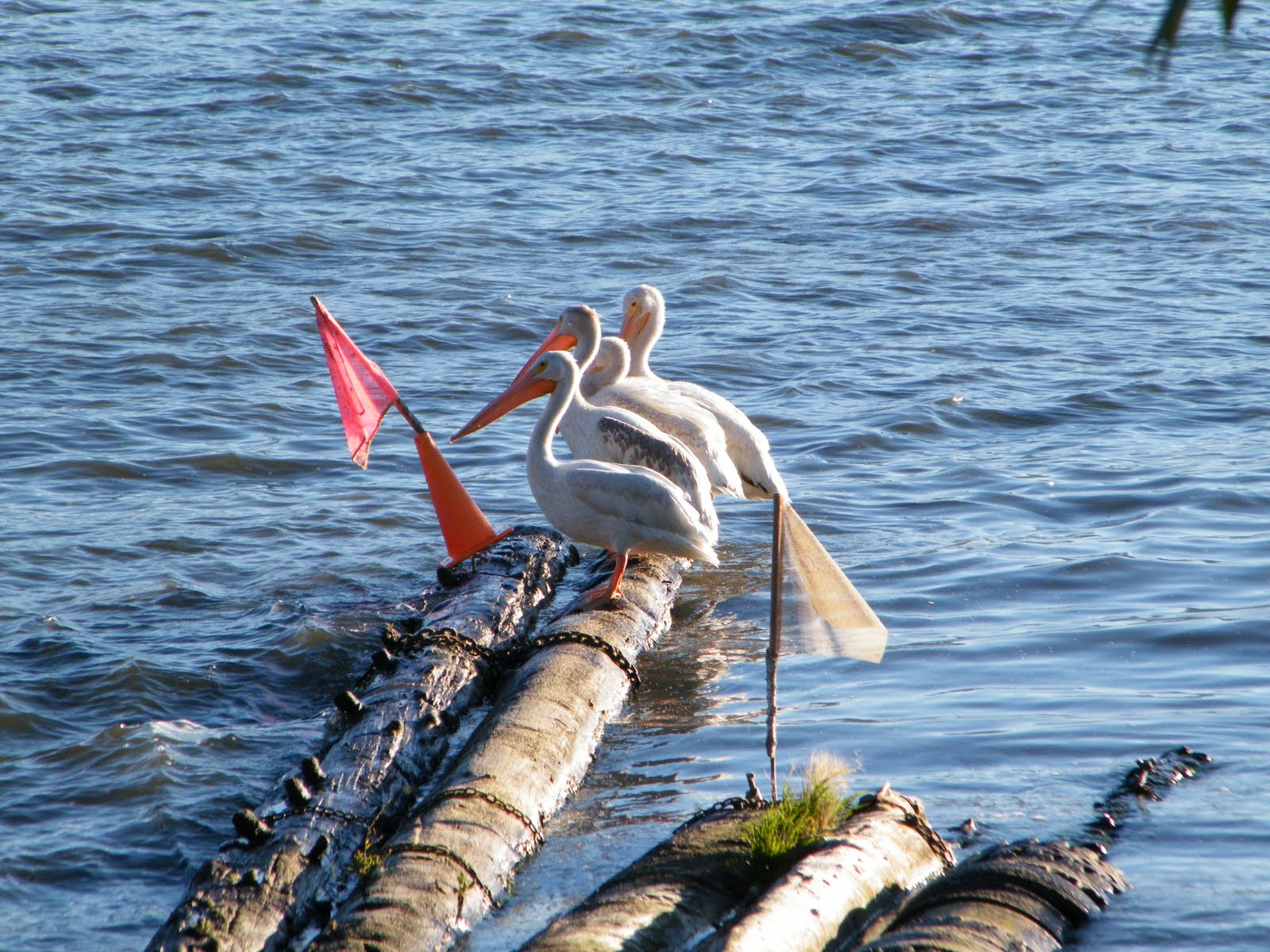
We walked down the hill from the motel to a nice seafood restaurant on the waterfront. Had a table overlooking the water where we could watch seals swimming past and pelicans dive bombing for fish.
 We left Spokane and headed west on Interstate 90. We turned off at Ritzville on to Highway 395 South and had a fuel stop at the town of Kennewick before branching on to Interstate 82 East and crossing over the Columbia River into the state of Oregon.
We rode west on Interstate 84 on a great road that overlooked the Columbia River. This route was the same taken by early explorers Lewis and Clark who left St Louis in the early 1800's and opened up what would become to be known as the 'Oregon Trail' for all the early settlers who would follow with their wagon trains.
After stopping for lunch at Boardman around noon we continued along the Columbia River Highway for another hour and a half. After rounding a bend just before our destination of the day (after a ride of 440kms) at the town of The Dalles we saw on the horizon the large mountain peak of Mount Hood, dwarfing the other peaks of the Cascade Mountains - very impressive.
The town of The Dalles (population 12,000) got it's name from french fur traders. 'Dalles' is french for 'sluice' and describes the effect the river had on carving out a path through the valley.
The next morning we decided to get on the road early due to an extreme weather warning for Oregon with temperatures predicted to be over 100f in places (about 38c). We set out on Highway 197 south and climbed through the foothills until we linked up with Highway 97 south. We had a view of the Cascade Mountains on our right and surrounding us were arid rolling hills of juniper and sagebrush, typical of the high desert country in eastern Oregon. In one place we saw a lot of squirrels foraging for food on the side of the road.
We stopped at a rest area where we met some other bikers who informed us that the HOG (Harley Owners Group) Rally of Oregon was on at the moment. Apparantly there is a group ride from Bend to Medford tomorrow via Crater Lake, so we may see a few bikes on the road!
Apart from this one stop we had a leisurely ride of only 220kms for the day. We stopped for lunch at our destination in the town of Bend (about 80,000 people) around noon just as the temperature was starting to soar. We checked in to a motel where the motel manager said that he had checked out two New Zealand motorcyclists that morning! I said; "Their names wouldn't happen to be Evan Fahey and Maurie Barrington by any chance?" The manager pulled out the check-in slip and confirmed it had been completed by Evan!
 It was sunny when we left Kalispell this morning, but still cold (around 45f or 7c). We took Highway 2 West. The ride was excellent as we passed through the Kootenai State Forest over rolling hills covered in pine and past a few lakes.
After a few hours of riding we had crossed the state line of Idaho and stopped at Bonners Ferry for fuel and lunch. Well, we actually had a second breakfast as we changed from Mountain Time to Pacific Time when we crossed the state line and gained an hour. What was 11:45am Mountain Time was still the middle of the breakfast menu at the diner in Bonners Ferry Idaho at 10:45am!
We branched on to Highway 2 South and rode to Coeur d'Alene and then linked up with Interstate 90 West. Within half an hour we had crossed the state line into Washington and reached the city of Spokane, our destination for the day. Spokane is Washington's largest inland city with over 200,000 people. The city was rebuilt with brick after a disastrous fire in 1889 and is the smallest city to have hosted a world fair (Expo 74).
After checking in to a motel, I decided it would be a good idea to find a car wash with a high pressure water blaster to wash the crud off the bike picked up from our wet excursion through Glacier National Park yesterday. We were given directions to a self-service car wash with bays that had high pressure hoses. There were vending machines where you could change notes for $1 coins to activate the wash. I placed a note into what I thought was a vending machine, but it turned out to be payment for the automatic car wash! Kiss goodbye to $5! Teach me for not reading signs! I then found what was the coin vending machine and placed a dollar note in the slot and received a coin. I then placed a second note in the slot and the 'out of service' light started flashing. Kiss goodbye to $1. I used the coin I received and that gave me 2 minutes of high pressure water to give the bike a quick rinse and then focus on washing the dirt and muck from under the chassis and fenders. An expensive wash - $7 all up. Tracee demonstrated extreme self control by not laughing at me.

 We left Jackson around 7:30am and headed west on Highway 22. We passed through the small community of Wilson and then started winding our way up Teton Pass. At that hour of the morning the air was chilly to say the least.
We crossed over the state line into Idaho (the potato capital of the USA), branched off at Victor on to Highway 33 and then on to Highway 20 for a scenic ride back over the state line into Montana and the town of West Yellowstone at the western entrance to Yellowstone Park. It was a great ride with rolling hills through Idaho and then a climb up to pine forested hills on the way to West Yellowstone. We saw a large stag with a good set of antlers on the side of the road. He ran back into the forest at the sound of the Harley rumbling past him.
Our reason for visiting West Yellowstone was to see the Grizzly & Wolf Discovery Centre. This is a wildlife sanctuary for rescued grizzlys and grey wolves as well as an educational facility. As we had yet to see them in the wild, we thought we would make sure we at least saw them rather than not at all! The day was warming up by the time we got there, so the wolves (like all canines on a hot day) were just lying in the sun. Not very exciting at all! The grizzlys however, were very impressive. We happened to time our visit at feeding time - which meant they were very active in overturning rocks and dead branches to discover the meat hidden by the rangers.
After our visit to the wildlife centre, we continued north up Highway 191 to Bozeman. We had been told by a shop owner in West Yellowstone that there had been a number of grizzly sightings in the last week or so along this road as it cuts through the western boundary of Yellowstone National Park. We were (nervously) hopeful we might see one - but it was not to be.
Bozeman is an agricultural town with a population of 27000. It is situated in the Gallatin Valley in the heart of what was once a sacred Sioux Indian hunting ground.


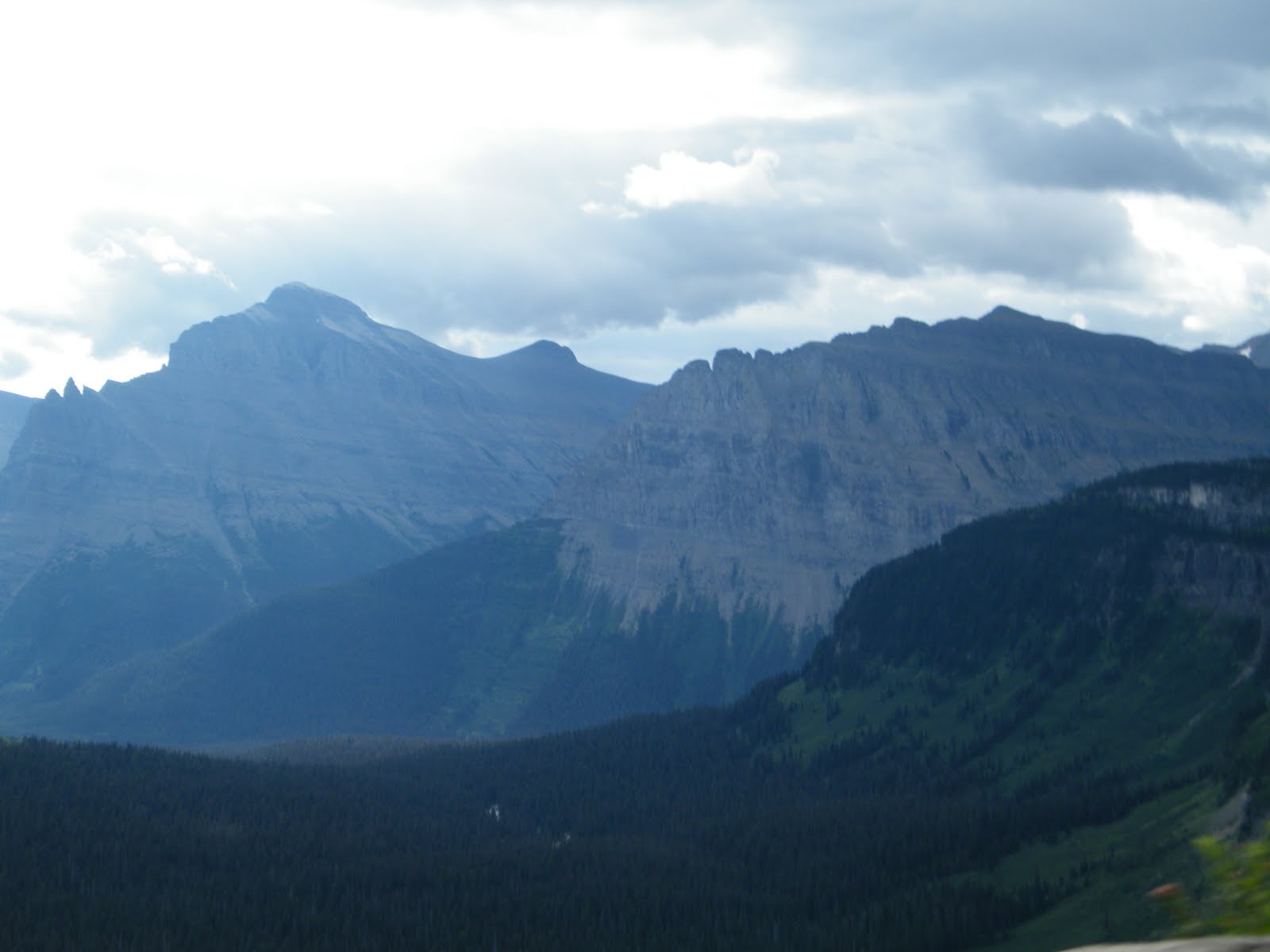
 It was a nice sunny morning with a freshness in the air as we headed out of Cody down 160km of Highway 14 to Yellowstone National Park. Yellowstone is the USA's oldest national park and spans across the states of Idaho, Montana and Wyoming. It is a volcanic plateau at an average elevation of 8000 ft and has over 10,000 hot springs and geysers (more than half the worlds total). We had been told that the east entrance to the park was the most scenic -and we were not disappointed - tall peaks, pine forest, rivers, the Cody Dam, a couple of tunnels through the hill, it had a real variety of scenery.
One key focus of this trip for us has been to visit as many national parks as possible, We have both had a particular interest in the wildlife, especially what you do not see back home. So far, we have seen bison/buffalo, white tail deer, bald eagles, vultures, prairie dogs, squirrels, chipmunks,and a porcupine. I won't count the skunk and two racoons as they were road kill! What is left for us to tick off are to see bears, wolves and moose in the wild. We were hoping that Yellowstone may help us tick off some of these yet unseen wildlife sights.
We were about 5km away from the east entrance when we saw a number of cars parked across the road from a trading post store. We pulled over to see what everyone was looking at. As we looked over the roadside barrier and down into a shallow gully we saw a female moose (a moosette?) grazing only about 150 metres away from us. She wasn't fazed in the least by all the human activity a short distance away. A big tick for that one - another one off the wildlife list!
We cruised on in to the park and wound past the huge Yellowstone Lake and past a meadow where we saw a herd of bison grazing. We stopped at a trading post at West Thumb to fuel up the bike and grab some lunch. We met a couple of Aussies on a Harley who had also shipped their bike over to the states. They had seen a grizzly and her cub walking through the park yesterday!
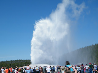
At the junction we turned on to Highway 20 and rode the 17 miles up the road to see 'Old Faithful' - Yellostone's famous geyser. Old Faithful 'blows' about every 90 minutes and we timed our arrival to perfection. We dismounted from the bike and walked into the visitor centre to ask the ranger when the next eruption was due. She said at 2:07pm. We had arrived at 1: 57 pm - perfect. In fact Old Faithful decided to go a few minutes earlier. We had just walked over to the viewing area when a plume of steam shot up into the air - quite impressive. Each eruption lasts about 5 minutes.
We retraced our route back down Highway 20 and then took Highway 191 south towards Grand Teton National Park. We were not far from the south entrance of Yellowstone when a huge elk stepped out of the forest on to the side of the road and sniffed the air just as we rode past.
We stopped at a lookout further down the road when Dave, Trevor & Liz from Ashburton (who had shipped their bikes with ours) rode up. They had also been in Cody last night and were making their way west after Yellowstone as they were shipping their bikes back in another week and a half. We had a good catch up and then rode together for a while.
We rode into Grand Teton National Park and pulled over at a lookout when the majestic Grand Teton Mountains came into view - stunning. Further up the road there were cars pulled over at the side of the road and people with cameras were very interested in somethhing down in the stream that ran alondgside the road. We pulled over and got off the bike and saw our second moose of the day - this time a large bull moose.
We ended the day at the classy tourist town of Jackson. The town is very 'western' and many shops specialise in leather goods, native american craft and western clothing. It was only mid week, but most shops were staying open to 9:00pm every day during the holiday season.